ABSTRACT: Amid growing typhoon risks driven by climate change with projected shifts in precipitation intensity and temperature patterns, Taiwan faces increasing challenges in flood risk. In response, this study proposes a geographic information system (GIS)-based artificial intelligence (AI) model to assess flood susceptibility in Keelung City, integrating geospatial and hydrometeorological data collected during Typhoon Krathon (2024). The model employs the random forest (RF) algorithm, using seven environmental variables excluding average elevation, slope, topographic wetness index (TWI), frequency of cumulative rainfall threshold exceedance, normalized difference vegetation index (NDVI), flow accumulation, and drainage density, with the number of flood events per unit area as the output. The RF model demonstrates high accuracy, achieving the accuracy of 97.45%. Feature importance indicates that NDVI is the most critical predictor, followed by flow accumulation, TWI, and rainfall frequency. Furthermore, under the IPCC AR5
RCP8.5 scenarios, projected 50-year return period rainfall in Keelung City increases by 42.40%–64.95% under +2○C to +4○C warming. These projections were integrated into the RF model to simulate future flood susceptibility. Results
indicate two districts in the study area face the greatest increase in flood risk, emphasizing the need for targeted climate adaptation in vulnerable urban areas.
KEYWORDS: Typhoon; artificial intelligence; random forest; geographic information system; flood susceptibility
https://doi.org/10.32604/cmes.2025.0706
海大團隊以AI與GIS建構「未來颱風洪災風險預測模型」
——揭示氣候變遷下基隆地區潛在洪患熱區,助力城市防災決策
基隆市,2025 年10 月 — 國立臺灣海洋大學河海工程學系研究團隊運用人工智慧(AI)與地理資訊系統(GIS)整合技術,成功開發出全球首創的「氣候變遷情境下颱風洪災風險預測模型」,以精準模擬未來極端降雨事件造成的都市洪水分布。研究成果已發表於國際期刊 Computer Modeling in Engineering and Sciences (CMES),展現臺灣在智慧防災與永續城市規劃領域的創新突破。
🌧️ 研究背景:氣候變遷加劇北臺灣洪災風險
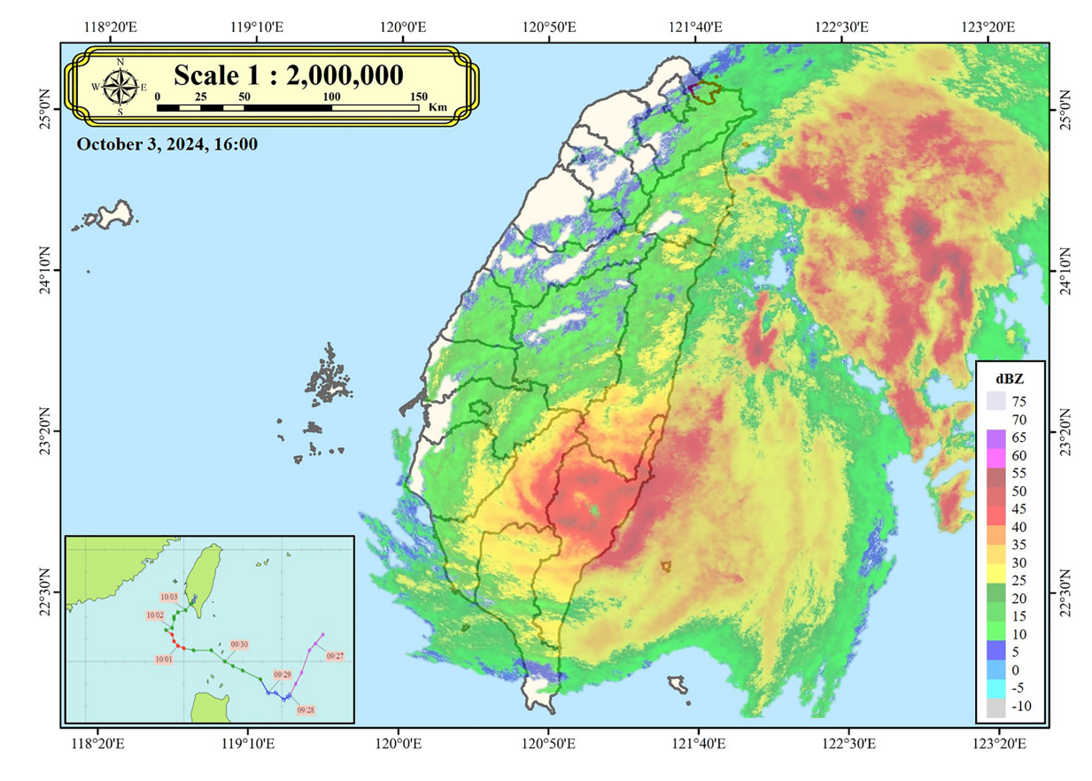
隨著氣候變遷導致降雨型態劇烈改變,北臺灣沿海城市的洪患頻率與強度顯著提升。研究團隊以2024 年克拉頓颱風(Typhoon Krathon)為分析核心,蒐集基隆市於該颱風期間的氣象與災情資料,建構地理與水文多源數據庫。
根據中央氣象署資料,該颱風雖未登陸臺灣,但外圍環流與東北季風共伴效應造成基隆單日最大降雨達 450.5 毫米,創下歷史新高,引發嚴重淹水事件。
🧠 技術創新:AI-GIS融合模型準確率達 97.45%
研究採用隨機森林(Random Forest, RF)演算法,整合八項地理與氣象因子,包括平均高程、坡度、地形濕潤指數(TWI)、累積雨量閾值超越頻率、植生指數(NDVI)、逕流累積量及河川密度等,建立AI洪災易淹模型。
透過**貝氏最佳化(Bayesian Optimization)**進行超參數調校後,模型在測試集上達成:
- 預測準確率 97.45%
- 解釋變異(R²) 0.84
- 均方根誤差 6.7 × 10⁻³
🌍 模擬成果:+4 °C 升溫下洪災風險恐增 逾 60%
根據IPCC AR5 RCP8.5高排放情境,團隊將全球升溫 +2 °C、+3 °C、+4 °C 下的降雨強度(50 年重現期雨量)納入模型模擬:
- +2 °C:雨量增 42.4%
- +3 °C:增 54.7%
- +4 °C:增 64.9%
結果顯示:
- 信義區與中正區未來洪災頻率上升最劇,
- 仁愛區亦呈顯著增加趨勢。
🏗️ 政策啟示:以AI引導城市防災新策略
研究指出,都市綠覆率(NDVI)對減災影響最顯著,顯示植生維護與綠基礎設施是未來防洪關鍵。
模型結果可作為政府與地方防災單位的決策支援系統(DSS),協助:
- 優先強化高風險流域排水設施;
- 規劃透水鋪面與滯洪池工程;
- 建立地區性智慧預警系統。
🧩 學術貢獻與展望
團隊後續將擴展至多颱風軌跡訓練及多情境模擬,期望建立全臺灣尺度的「AI智慧洪災預警平台」,推動智慧防災城市的實現。
📖 研究出處
Chih-Yu Liu, Cheng-Yu Ku*, Ming-Han Tsai and Jia-Yi You (2025), ” AI-Driven GIS Modeling of Future Flood Risk and Susceptibility for Typhoon Krathon under Climate Change”, CMES-Computer Modeling in Engineering & Sciences, 2025.070663, pp. 1-22. (SCIE, IF 2.5, Q1, 31/136 (22.4% JIF) in MATHEMATICS, INTERDISCIPLINARY APPLICATIONS, JCR 2024)
https://doi.org/10.32604/cmes.2025.070663